Good morning. This is Ian Hoyer with the Gallatin National Forest Avalanche Forecast on Saturday, April 1st at 7:00 a.m. This information is sponsored by Uphill Pursuits and Avalanche Alliance. This forecast does not apply to operating ski areas.
There are 3-4” of new snow around West Yellowstone and Cooke City, with 1-2” around Bozeman and Big Sky. Winds are SW-W at 15-25 mph with gusts of 30-55 mph. Temperatures are in the teens and 20s F. High temperatures will be in the 20s and 30s F. Gusty SW-W winds will continue. Snowfall will ramp up late this afternoon with a couple inches falling by nightfall and 6-8” by morning across much of the advisory area with about half as much expected around Bozeman.
You can trigger an avalanche today in wind drifts formed either from the snow that fell last night or the snow that fell over the last week. Drifts in today’s new snow will be thinner, but more easily triggered. These slides could still easily be 1-2 ft deep in places where it’s snowed more, which is plenty of snow to bury you in the wrong terrain or carry you into rocks or trees. The older drifts will be a bit harder to trigger, but also break deeper and larger. Yesterday, a fresh natural wind slab was seen on Cedar Mountain (photo) and riders in Portal Creek triggered a 2-3 ft deep avalanche from 100 ft away (details and photos). The slide in Portal Creek likely broke on a weak faceted layer beneath last week’s snow that has remained unstable. Watch for shooting cracks as a clear sign that the newly wind drifted snow is ready to avalanche. Dig down to test the top 3 ft feet of the snowpack before getting onto steep slopes.
Triggering deep slab avalanches also remains a scary possibility. On Thursday, a snowboarder took a big ride over huge cliffs in a slide that broke deep in the Lone Lake Cirque, near Big Sky resort (photo). These deep slabs are the prototypical low-frequency, high consequence concern. It’s been over a week since other deep slabs were triggered (Elephant Mtn., Daisy Pass), but if you do trigger one it will be very dangerous. Your options are either to avoid steep slopes entirely or to roll the dice and hope you aren’t the one that gets really unlucky. Stack the deck in your favor by choosing smaller slopes without additional hazards in the runout zone, going one at a time, and having a partner watching from a safe spot.
The avalanche danger is rated MODERATE on all slopes.
Please share avalanche, snowpack or weather observations via our website, email (mtavalanche@gmail.com), phone (406-587-6984), or Instagram (#gnfacobs).
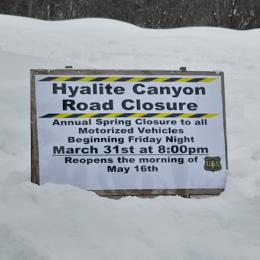
Hyalite Canyon road is closed for motorized use until May 16.


